 Reuters

[Source: Reuters]
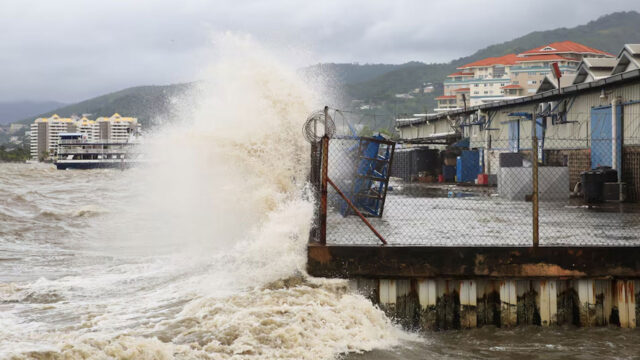
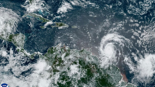
Hurricane Beryl unleashed powerful winds over the Eastern Caribbean on Monday, downing power lines and ripping roofs from buildings, as scientists argue that climate change likely added to how quickly the unusually fierce, early storm formed.
Beryl struck the southeastern Caribbean at Category 4 strength on the Saffir-Simpson five-point scale, spiraling toward the Caribbean’s Windward Islands and threatening devastating flooding as potentially deadly winds picked up speed.
“This is an extremely dangerous and life-threatening situation. Take action now to protect your life!” the U.S. National Hurricane Center said in a post on Monday, urging residents in Grenada, the Grenadine Islands as well as Carriacou Island to shelter in place due to an expected rapid increase in wind force.
Across many islands that dot the Eastern Caribbean, residents boarded up windows, stocked up on food and filled their cars with fuel as the storm drew closer.
The Miami-based hurricane center noted that hurricane-force winds spread out from Beryl’s well-defined eye by up to 40 miles (64 km), with still-dangerous tropical storm force winds extending outward by another 125 miles (201 km).
Beryl’s rapid rise marks an unusually fierce and early start to this year’s Atlantic hurricane season, including the earliest Category 4 storm on record.
Scientists surveyed by Reuters see the powerful hurricane as a harbinger of an unusually active hurricane season made possible by record-high temperatures in the Atlantic Ocean.
“Climate change is loading the dice for more intense hurricanes to form,” said Christopher Rozoff, an atmospheric scientist at the United States’ National Center for Atmospheric Research in Boulder, Colorado.
Andra Garner, a New Jersey-based meteorologist, noted that Beryl jumped from a Category 1 to a Category 4 storm in less than 10 hours.
Leaders in the region sought to prepare locals for the worst, including the prime minister of St. Vincent and the Grenadines, Ralph Gonsalves. He said he was expecting a natural disaster that could continue for days.
“We have to wait this monster out,” he said in an address to the nation.
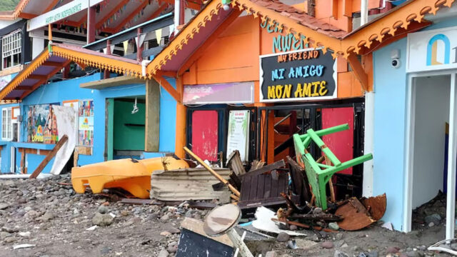
In the capital of Kingstown, conditions around the main harbor worsened on Monday morning, with some damage to buildings reported, caused by intensifying winds. Video from the city showed waves crashing over a seawall and palm trees along the shore battered by the wind.
Beryl’s maximum sustained wind speed had risen to 150 miles (241 km) per hour by Monday afternoon, with the weather phenomenon located about 65 miles (105 km) northwest of Grenada.
Beryl is moving west-northwest at a speed of 20 mph (32 kph), the U.S. hurricane center said, and is forecast to cross many of the central Caribbean’s most populated islands through Wednesday as it barrels toward the Gulf of Mexico.
The core of the hurricane will likely bring “potentially catastrophic wind damage” as it moves through the Windward Islands, with St. Vincent and the Grenadines, and Grenada most at risk, according to the center.
In the St. Vincent community of Prospect, damage reports included roofs ripped off of buildings, as well as power cuts in other parts of the island.
A Reuters reporter on Grenada said power was down across the island.